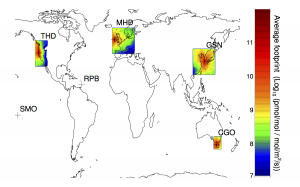
In the AGAGE network, we have a small number of monitoring stations, which measure greenhouse gases at high frequency. I’m interested in using these high-frequency measurements to estimate emissions from the countries surrounding the sites. To connect the measurements to sources, we require chemical transport models (see some animations here). However, when we use global models, they take a lot of computer time to run, particularly at high resolution, which is needed when we’re trying to estimate emissions on national scales. Sometimes it makes sense to run a model at very high resolution close to the measurement sites (where we have the most information about emissions) and low resolution everywhere else. This was the problem we tried to tackle in this paper, co-written by colleagues at the UK Met. Office.
The method we developed takes the output from two different types of model and couples them together so that we could estimate emissions at very high resolution close to the monitoring sites, and low resolution further away.

We’ve used this method, along with the the Met Office NAME model and NCAR’s MOZART model, to determine SF6 emissions around four AGAGE sites (see the figure), and will be extending it to all the other AGAGE gases in the near future.
The code for the project can be found at Google code: http://code.google.com/p/mr-cels/
